
By Michelle Portesi
.
Here at ‘Your Friend In High Places’, the plan is to get all of our favorite hikes archived on the blog. There are many popular hikes in the area that are local favorites. Yet, with so much close access to the High Sierra back country, there are always new ones to discover.
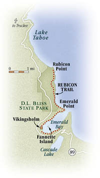
This post is focusing on The Rubicon Trail out of D.L. Bliss State Park on Tahoe’s West Shore. The California State Park and Campground is located on the lake side just before Emerald Bay. Day parking is $10 per car. If you frequent our state parks often during the year and don’t already have a membership pass, you might want to spring for one of the many day use options the California State Park Foundation has to offer that can really save you some money.

Along the Rubicon Trail, West Shore, Lake Tahoe (Photo by Michelle Portesi)
.
After turning into the park, drive all the way down to the bottom (You’ll be paying your fees at the campground kiosk near the day use beach and hiking parking lots.) There are bathrooms at the parking lot, so take the opportunity, as you will not see another bathroom until you get to the boat campground on Emerald Bay. While you can turn around at any time, if you want to make it to Emerald Bay, plan for this hike to take most of the day. This is a relatively easy to moderate hike, but I guarantee that you will be stopping to take many photos along the way.
The Rubicon Trail out of Bliss follows the lake for most of the way to Emerald Bay. You will be high above the lake for panoramic views, occasional glimpses of osprey and/or their nests and insanely vivid hues of blue waters. What makes this hike so amazing is the underwater geography of this particular part of the lake. Many millennia ago, part of the lake’s rim in this area sheered off down to the incredible depths below, creating sheer drop offs from the waters edge. In these areas, the color of the water stuns in deep shades of cobalt blue, as if someone had dropped many gallons of dye off Lake Tahoe’s shore. Further along the hike, shallow coves appear with white sand bottoms, in as many vivid shades of aqua as any exotic oceanic island.
.

Boating in cobalt waters, Lake Tahoe (Photo by Michelle Portesi – no photo color adjusting required…)
.
As you near Emerald Bay, there is a separate trail that veers to the left that will take you to the headland of the entrance to the bay. Here you will see the many boats on the lake that come for a glimpse of the bays many charms.
Back on the main trail that veers to the right, you are now down close to the shoreline. Many sandy beaches appear along the way. Continue on to the boat campground, thus named because most people boat in their camping gear for a stay instead of slogging it the long hike down. (Only park rangers and the camp host is allowed to drive down the fire road to the campsites.) From here you can view Fannette island in the middle of the bay, with the still visible remains of the stone tea house where the original owners used to ferry their guests for high tea in the afternoons. You can also see part of Eagle Falls in the distance.
If you’re feeling up to it, you can continue along the trail to the Vikingsholm Historic Site and the museum right next to it at the end of Emerald Bay. (Bring money with you if you want to do the tour through the estate). While you could theoretically hike back up to the highway from here, remember, your car is still at the base of Bliss State Park several miles away. Unless you’ve got some elaborate carpool plans going, most of us just turn around and hike the Rubicon trail back to our cars.
Congratulate yourself on getting a substantive amount of exercise. Now treat yourself to a margarita or an ice cold beer at one of the many West Shore establishments. You’ve earned it!
.
Rubicon Trail, Lake Tahoe
.


Pingback: Go Take A Hike, Part 6. Eagle Falls and Eagle Lake | YOUR FRIEND IN HIGH PLACES