Archive for the ‘Summer Recreation’ Category

By Tim Hauserman
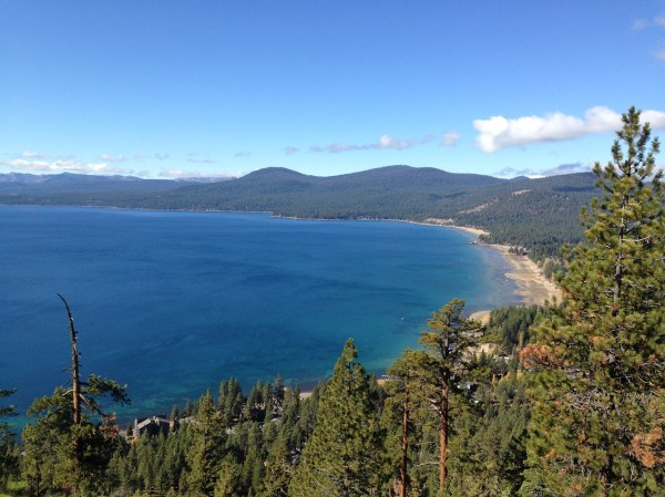
In the fall of 2015, I made the short journey to the Stateline Lookout above Crystal Bay. It’s a fairly short hike that rewards you with spectacular views of Lake Tahoe, from two very different perspectives: One towards the south and east over Incline Village, and the other straight towards Kings Beach. I made the trek again this week, and was rewarded not only with those jaw dropping views, but also the stark evidence of how water has poured into Lake Tahoe during this monumental winter.
Check out these photos taken from the exact same spot: The rock patio area where the actual fire lookout used to stand. The first in the fall of 2015 depicts a wide, glorious beach in front of Kings Beach, and the second, taken on March 18th, shows the swath of sand has almost disappeared under Tahoe’s sparkling waters.

The other difference with the hike this time, was that it was mostly on snow. In the summer a paved single land road (blocked for public traffic) leads up to the top, where several paved hiking paths take off. This time, the first half of the route was down to pavement, as the road is plowed to the water tank just above the route. From there, you are walking over several feet of snow. The day we hiked, was after a week of warmness so the main route had been nicely packed down by a steady supply of visitors. Once we headed off the trail, to check out the views from the edge of the ridge, we ventured into “post-hole” land: where every step you hoped you would stay afloat and not drop down a foot, once my foot dropped about two feet.
Given the winter we’ve had, it is pretty nice to give your feet a chance to ramble, and with this short climb, you are rewarded with two amazing views. Enjoy.
Where to begin:
Take the first left off of Highway 28 on the Incline Village side of the North Shore casinos at Reservoir Road. In a short distance, turn right on Lakeview (where you will see a sign that says Lookout). Take a left at the first “Y”, then at the next “Y” your trail begins behind the gate on the left. It’s a residential area with just a few parking spaces, so try to go on a weekday. You could also park at the The Biltmore and walk up the road, which would add a pleasant mile to the hike.
THINK OF ME, LYNN RICHARDSON, FOR ALL OF YOUR LAKE TAHOE AND TRUCKEE REAL ESTATE NEEDS!
Share this: Lynn Richardson, Your Friend in High Places
By Tim Hauserman
.

.
Once Highway 40 was known as the Lincoln Highway, and was the main route across the Sierra between Sacramento and Reno. Little towns such as Big Bend and Cisco Grove were places to eat, pick up some groceries, or purchase a gift before the final push over Donner Summit into Truckee. With the completion of Interstate 80, the commercial establishments along much of Highway 40 died away, but many of the original buildings and character of the communities still exist.
Cisco Grove has Gould Park, a 15 acre swath of greenery on the banks of the bustling Yuba River. From here begins the 20 Mile Museum, which includes dozens of interpretative signs along Highway 40 all the way to Donner Lake. Each sign tells the story of where you are and gives ideas for things to do nearby.
.

.
Cisco Grove contains a host of fascinating buildings, many constructed of rock. Just another mile or so up Highway 40 lies Big Bend. On the way, be sure and marvel at the mini rapids in the Yuba River as you travel underneath Interstate 80.
Big Bend is home to a major Forest Service Fire Station, campground, the popular Loch Leven Lakes trail, and ancient cabins tucked along the Yuba River. A bit further upstream you reach The Rainbow Lodge, and then a series of fascinating cascades which splash over the smooth granite. A few lucky homes sit tucked amongst the rocks enjoying delicious natural pools in their back yards.
.

.
While Old 40 is a leisurely drive, the best way to see Big Bend and Cisco Grove is via bicycle, in fact it is one of the most popular bike rides in the area. The road is lightly traveled, but well maintained, and the ride is pleasant and beautiful. It is also deceptively challenging. From the top of Donner Summit to Cisco Grove feels like a nice gentle descent while riding west, but feels like a long, not as gentle as you thought, ride back to the top. Especially the section between Kingvale and Soda Springs. It feels easier to start in Cisco Grove and warm up with the climb.
Whether you drive or ride, a visit to Cisco Grove and Big Bend, is a perfect way to break up the drive from the Bay Area to Truckee, and will feel like a step back in time.
.

.
THINK OF ME, LYNN RICHARDSON, FOR ALL OF YOUR LAKE TAHOE AND TRUCKEE REAL ESTATE NEEDS!
Share this: Lynn Richardson, Your Friend in High Places

By Tim Hauserman
Looking for a Tahoe hike away from the crowds on an August weekend with spectacular views? Try spending your morning hiking to the top of Ward Peak like I did this past Saturday. While I only saw two people, I was treated to views of Ward Canyon, the Granite Chief Wilderness and Lake Tahoe along the route and from the 8637’ summit of the peak.
Begin your hike at the base of Alpine Meadow’s Sherwood Chairlift. To get there: Take Pineland Drive off Highway 89 just south of Sunnyside Lodge, and follow it to a Y and a sign that says “Ward Valley.” Follow the road as it winds through Pineland and becomes Ward Creek Blvd.. Soon you emerge from the houses and enjoy a three mile jaunt along Ward Creek climbing through Ward Canyon. The road becomes Courchevel when you reach Alpine Peaks. Follow to the end where you find parking on your left.
The hike follows the Alpine Meadows maintenance road to the top of the Sherwood Chair. It’s a steady, but gentle climb through open terrain with constant views of Twin Peaks, Lake Tahoe and the Pacific Crest above. Enjoy the soft crinkling of drying mule ears rustling in the breeze, as you rise, the views of lake and mountains seeming to get better with each step. Eventually you reach the top of the Sherwood chairlift and the end of the dirt road.
.

.
Now, take a quick steep jaunt up a slope to the remains of an old cat track, which switchbacks further up the ridge towards Ward Peak. A few steep turns and you reach the open nearly flat ridgeline above the famous F-Tree at Alpine Meadows. After about an hour of steady walking this can be your destination as it gives you 360 degree views of Lake Tahoe, Twin Peaks, Ward Peak, Alpine Meadows, and the Truckee River Corridor.
If you got it in ya’, however, take another 15 minutes of ridgetop climbing to reach Ward Peak’s summit. Follow the obvious route and do a bit of rock scrambling and you will soon enough be atop the peak where you find a bunch of cell towers and a helipad. From here, a whole new panorama opens up of Granite Chief Wilderness and the Pacific Crest Trail below you to the west. Once you’ve had your fill, retrace your steps and go jump in the lake.
.

.
THINK OF ME, LYNN RICHARDSON, FOR ALL OF YOUR LAKE TAHOE AND TRUCKEE REAL ESTATE NEEDS!
.
Share this: Lynn Richardson, Your Friend in High Places